Because there’s lots of good stuff already out there, each season arcCA DIGEST scours the Internet for material that addresses the topic at hand. In this edition of “Sources,” we bring you three articles on artificial intelligence and architecture (a phrase that simply begs for a joke), an article on the use of data in urban cartography, and a collection of open government data portals.
AI & Architecture
 “How Can Architects Adapt to the Coming Age of AI?” from The Architect’s Newspaper
The Architect’s Newspaper is what it sounds like, except smarter and better looking. Its print edition (nine issues per year) and design & culture magazine, AN Interior, are available free to licensed architects and landscape architects. Architect and technologist Phil Bernstein, FAIA, who authored this article in November 2017, also weighs in on our regular feature, “What To Look For.”
 “Excessive Resolution: Artificial Intelligence and Machine Learning in Architectural Design,” from Architectural Record
Architectural Record began publication in 1891. When it merged with American Architect and Architecture, first published in 1876, the nation’s two oldest architectural magazines became one. In this article from 1 June 2018, Mario Carpo compares how computers think and how we think: “Machines search—big data is for them. We sort: compressing data (losing or disregarding some in the process) is for us. With comparison, selection, formalization, generalization, and abstraction come choice, meaning, value, and ideology, but also argument and dialogue.”
 “Doom or Bloom: What Will Artificial Intelligence Mean for Architecture?” from Common|Edge
Common|Edge is a non-profit organization/publication whose goal is “to generate the resources necessary to research, publish and advocate for a community of engaged designers, writers, public servants, and activist citizens who are committed to creating designs that manifest the highest aspirations of a democratic society.” In this article from 17 September 2018, Michael J. Crosbie interviews Imdat As, a researcher whose work includes “Artificial intelligence in architecture: Generating conceptual design via deep learning,” published in the International Journal of Architecture and Computing, 28 September 2018.
Data & Maps
 “Urban Cartography,” from The Urbanist
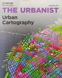
The Urbanist is the magazine of SPUR, the San Francisco Bay Area Planning and Urban Research Association, an extraordinarily effective non-profit city planning organization with offices in San Francisco, Oakland, and San Jose. Noting that, “There has never been so much data available as there is now. More and more people are using it to make maps that are transforming the way we design, build and understand cities,” Allison Arieff reviews the exhibition “Urban Cartography” held at SPUR’s San Francisco gallery 23 October 2014 – 6 February 2015.
Open Government Data
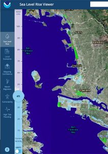 Data.Gov is the portal to the U.S. Government’s open data. It comprises over 250,000 datasets, many of which bear on the built environment. For example, at the time of this writing, there are 193 datasets on sea level rise for San Diego County. These datasets can be highly technical; more accessible is the Sea Level Rise Viewer, where you can explore projected sea level rise by year through the end of the century, across a range of scenarios; the page for San Diego is here. The Sea Level Rise Viewer is one of several tools developed by the National Oceanic and Atmospheric Administration (NOAA). Two others are the U.S. Climate Resilience Toolkit and the Climate Explorer.
These resources are made available to the public in accordance with the White House Memorandum on Transparency and Open Government of 21 January 2009. This initiative is part of an international movement to make government more transparent, accountable, and collaborative. Many municipalities in California, from big cities to small towns, have adopted open government policies and developed data portals. Among them are:
Southern California Association of Governments Open Data
City of Elk Grove GIS Data Gateway
Los Angeles County GIS Data Portal
From arcCA DIGEST Season 4, “Data.”