Every weekend, thousands of Southern Californians head for the hills. They head for the San Gabriels in Angeles National Forest, for the Santa Monicas in Griffith Park. In the mountains surrounding the city, Angelenos seek escape from the city’s smog, noise, and congestion. Like Thoreau, we seek nature, in search of physical, spiritual or emotional renewal. Our identification of nature as “out there,” away from the city, is as old as Virgil’s Eclogues.
During the winter, monsoon storm waters cascade out of these mountains and their picturesque arroyos into the valleys and coastal plains. Historically, these floodwaters overwhelmed the usually dry channel of the Los Angeles River, spreading across much of what today constitutes the urbanized area of greater Los Angeles. Following the disastrous flood of 1938, the Army Corps of Engineers fixed the river’s course in concrete channels, in what remains one of the largest public works projects west of the Mississippi. The result is a river that looks more like an empty freeway than the “beautiful, limpid little stream” William Mulholland described in 1877. Today, the river is a largely forgotten landscape, except for the occasional appearance in movies (Them!, Grease, Terminator 2) and storm coverage newscasts (“Rain Pounds the Southland”). Perhaps for those who appreciate the minimalist sculptures of Donald Judd, Richard Serra, or Robert Smithson, the concrete river channel has a certain stark beauty. Like an enormous work of land art, the wide, vacant, abstract space of the river is a silent void in the middle of the city, whose emptiness signifies a form of spiritualism. For most of us, however, the Los Angeles River—one of the most environmentally degraded and maligned rivers in the country—is a most unlikely place to seek nature. Yet if we value nature in the mountains, why not also in the city? What hope is there that the Los Angeles River might be perceived as a natural landscape, with meaning for the individual and body politic?
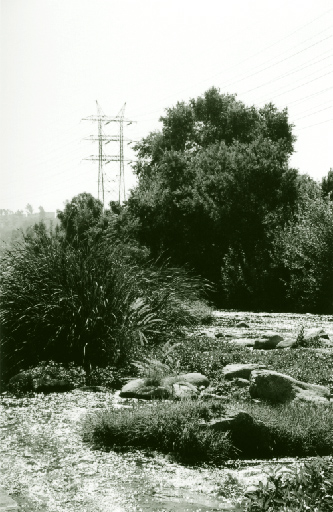 Glendale Narrows.
Although most of the river is encased in concrete, sections of it have a more river-like appearance. A thicket of sycamores and cattails grows in the Glendale Narrows, the eight miles between Griffith and Elysian Parks, where the high water table forced the Corps to accept cobblestones and sand instead of concrete as the river bottom. With the scenic hills of Griffith Park as a backdrop, it is possible here to imagine what the historic landscape of the river looked like, notwithstanding sloped concrete embankments and the noise from the adjacent 5 freeway. Here, organizations like North East Trees have pioneered a series of pocket parks, employing local artists and at-risk youth. Located in odd, leftover spaces between the public works flood control fences, private property, and the concrete embankments, these parks demonstrate that no site is too small for river greening. These parks—just big enough for one or two benches—are scaled to the individual or small groups. One, a passive fitness course, is a linear series of shaded stops, each with a plaque describing a yoga position. Other sites, like Rattlesnake Park in Frogtown and Anza Picnic Area at Los Feliz Boulevard, are simply landscaped gateways to the river, literally marked with formal gates and wildlife sculptures. These parks are a threshold between the landscape of the city and the landscape of the river, and they have introduced many people to the river. They have helped people appreciate the river’s beauty and demonstrated its recreational potential and value as a public space within the city. Most importantly, these pocket parks are showcases for other, larger, potential river restoration projects.
Just downriver from the Glendale Narrows, construction is scheduled to begin on Confluence Park, at the intersection of the Los Angeles River and the Arroyo Seco, under the 5 and 110 freeways. Where today there is an industrialized parking lot for County and CalTrans trucks, river advocates see the hub of a future 51-mile long L.A. River Greenway. This is river central—from here, gardens and paths will reach north through the Glendale Narrows up to the San Fernando Valley, northeast to Pasadena via the Arroyo Seco, and south to Downtown and the working class cities of south Los Angeles. Reclaiming the confluence site is not merely a park-building exercise; it is as an effort to renew communities’ connections to each other. It is also an attempt to renew the city’s historic connection to place: the confluence was the only site in the region where a year-round supply of water could be located, the impetus for founding El Pueblo de Los Angeles downhill in 1798. At Confluence Park, the real ambitions of river restoration become evident—hopes that greening the river will not only produce bike paths and shaded benches, but also create physical and psychic links among neighborhoods, history, and nature.
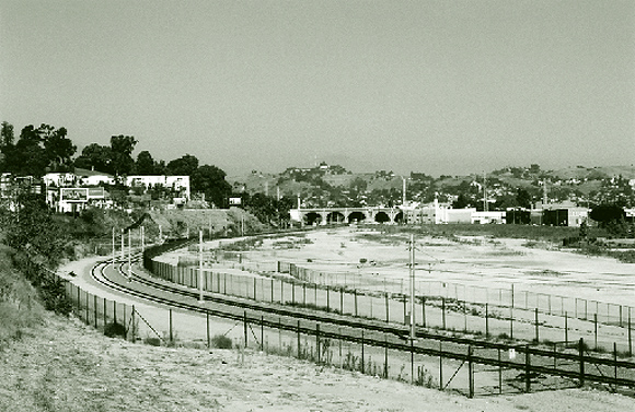
 River Channel at the Confluence.
Currently, local community groups and the City are working with State Parks to create two large urban parks from abandoned rail yards adjacent to the river. At Chinatown Yard (long known as the Cornfield), just downstream from the confluence, the connection to the river is of high symbolic and historic significance, since it is here that the Zanja Madre, the original aqueduct, delivered river water to the pueblo and its agricultural fields. Taylor Yard, upstream from the confluence in the Glendale Narrows, features over two miles of river frontage. Conceptual drawings suggest breaching the concrete walls to create sixty acres of wetlands, in addition to soccer fields and other normative park amenities. Both sites will create significant recreation areas for crowded neighborhoods with a shortage of parks and public space. But more importantly, both projects are underway because river groups joined with broad-based community coalitions to resist typical industrial development schemes. At the Cornfield and Taylor Yards, the river became a common umbrella for groups committed to historic preservation, ecological restoration, watershed management, and social justice. The Los Angeles River has become a “civic” space, gathering the city’s diverse populace.
 Cornfield Yard, looking north towards Broadway Bridge.
The Taylor Yard project additionally indicates that the most ambitious plans for the river aim to restore the river as a productive landscape—to create multi-functional public spaces that integrate flood-control engineering, recreation fields, and wildlife habitat. Thus far, new parks along the Los Angeles River have been on the river, but not “of” the river— they are essentially river-overlooks, located atop the concrete embankments. If the Taylor Yard project is successful, it will be the first of the new parks to physically engage the river’s ecology and merge it with the public life of the city. The yearly cycle of water in the river will flow in and out of the park, renewing its landscape. It will begin to renew the relationship between the ecological and civic life of the region, a relationship that arguably has been lost since the Americanization of Southern California.
The non-profit Friends of the L.A. River (FoLAR) recently unveiled similar plans for the Union Pacific Yard just east of downtown L.A. Developed by students from Harvard’s Landscape Architecture program, these conceptual studies propose strategies ranging from diversion channels to temporary dams to create ponds, lakes, and new wetlands in what are some of the most industrialized areas in the city. If such strategies are implemented, they will be the most dramatic attempts to integrate the ecology of the river with the neighborhoods and districts adjacent to the river channel. The prospect of river-nourished parks, community gardens, recreation trails, fishing ponds, and even beaches running along the east edge of downtown requires a major leap of imagination. Yet this is the vision of FoLAR and other environmental groups in the Los Angeles region. They imagine a future in which environmental restoration of the river also gives it a public face, civic presence, and cultural meaning.
Today’s pocket parks on the Los Angeles River are portals onto tomorrow’s restored ecology, revived neighborhoods, and renewed city. They are glimpses of an urban landscape where the river not only connects the mountains and the sea, but also neighborhoods and citizens. They suggest a city where the cycles of the natural world have presence, value, and meaning in public life—where the expression of the genius loci and the civic realm are one in the same.
Author Alan A. Loomis is an urban designer at Moule & Polyzoides Architects and Urbanists in Pasadena, where he has directed master planning projects for UCSB, Pomona College, the City of Azusa, and various cities in Monterey and San Luis Obispo Counties. He is a board member of the Los Angeles Forum for Architecture and Urban Design, where he directs web publications, and the creator/editor of www.DeliriousLA.net, a comprehensive weekly listing of architecture events in Southern California. A graduate of SCIARC, he co-edited the school’s student journal, Offramp 7: Detours and Dialogues (New York: Princeton Architectural Press, 2000).
Originally published 4th quarter 2003, in arcCA 03.4, “Reflect Renew.”